Sunday, July 19, 2026
START: TMP Taneytown Memorial Park, Taneytown, MD --
Don't miss the club's Annual Picnic - great rides for all paces, delicious buffet and plenty of time for socializing. And it's FREE for all members.
MUST REGISTER BY JULY 18 Click on homepage picnic icon for details and directions to the park.

START: Taneytown Memorial Park -- Ride Terrain: Rolling With Hills, Regrouping: Some, Rest Stops: Snack, Rain Cancellation: Go No Matter What
Tcx url: https://ridewithgps.com/routes/47439110
START: Taneytown Memorial Park -- Ride Terrain: Rolling With Hills, Regrouping: Some, Rest Stops: Snack, Rain Cancellation: Go No Matter What
Web Link: https://baltobikeclub.org/index.php/cue-library/Carroll-County/Under-50-Miles/BBC-2024-Picnic-48/
Tcx url: https://ridewithgps.com/routes/47410326
START: Taneytown Memorial Park -- Ride Terrain: Rolling, Regrouping: Some, Rest Stops: Snack, Rain Cancellation: Go No Matter What
Web Link: https://baltobikeclub.org/index.php/cue-library/Carroll-County/Under-50-Miles/BBC-2024-Picnic-38/
Tcx url: https://ridewithgps.com/routes/47410512
START: Taneytown Memorial Park -- Ride Terrain: Rolling With Hills, Regrouping: Some, Rest Stops: Snack, Rain Cancellation: Go No Matter What
Tcx url: https://ridewithgps.com/routes/35487641
START: Taneytown Memorial Park -- Ride Terrain: Rolling, Regrouping: Some, Rain Cancellation: Go No Matter What
Tcx url: https://ridewithgps.com/routes/43502829
Monday, July 20, 2026
START: VBC - Veloccino Bike and Coffee -- Ride Terrain: Rolling With Hills, Ride Leader's Pace: 14 mph, Regrouping: Some, Rest Stops: None, Rain Cancellation: Precipitation >60%
Weather looking great for a Monday morning ride. Come and join me for this beautiful ride through horse country. If you need more miles, start from Oregon Ridge Park and meet me at VELOCCINO. Hope you can join me. We can have a quick break leaving Prettyboy if need be. Tcx url: https://ridewithgps.com/routes/48159386
Tuesday, July 21, 2026
START: Butler Fire Station / Veloccino -- Ride Terrain: Rolling With Hills, Ride Leader's Pace: 16 mph, Regrouping: Some, Rest Stops: Snack, Rain Cancellation: Precipitation >60%
Check Calendar/Forums for any weather related changes / chances of rain.
Peasant roll north from Butler to PA on Grave Run Rd to Lineboro with a return on Alesia and Millers Station to Black Rock. A-Town Snack break at mile 26. About 3400 ft overall.
Optional start from Oregon Ridge about 8:15am for 45 miles overall.
Come join the Fun!
Grab a fresh download while you are here:
https://ridewithgps.com/routes/51738622
Tcx url: https://ridewithgps.com/routes/51738622
Saturday, July 25, 2026
START: Sandy Walk Way, Odenton MD -- Ride Terrain: Flat, Ride Leader's Pace: 10 mph, Regrouping: Frequent with Sweep, Rest Stops: None, Rain Cancellation: Sprinkles
Join us for a casual ride to sample the WB&A trail and cross the new Patuxent River bridge! This bridge was a long time in the making, and it now connects the Anne Arundel and Prince George county trails together, providing a key connection for trails between Baltimore and DC. https://greenway.org/stories/new-wb-a-trail-patuxent-river-bridge-strengthens-maryland-s-east-coast-greenway-linkThe leader’s route will include stops to see two bridges and at the turn around in the Horsepen Park lot. For those who want more riding, we can suggest side trips through the Two Rivers community, or there is always more trail north and south. We will plan to meet at the end of the ride at either the Lime & Salt restaurant or at Crooked Crab Brewery based on our votes.
Parking: Although there is a parking lot on Sandy Walk Way, with all the private signs showing, we advise street parking between the parking lot and the stop sign at Little Patuxent Court. We will start riding at the beginning of the Lone Wolf trail through the Piney Orchard Nature Preserve. Directions to Sandy Walk Way are linked above.
Web Link: https://maps.app.goo.gl/HSkvhh4fdWiUgf3o7?g_st=ipcTcx url: https://ridewithgps.com/trips/337648226
Sunday, July 26, 2026
START: Davidsonville Park 3042 Patuxent River Rd, Davidsonville, MD 21035 -- Ride Terrain: Flats And Hills, Ride Leader's Pace: 16 mph, Rest Stops: Lunch
3rd annual M.H. memorial ride to the beach & back. Lunch at Chesapeake market. Ride start / park has restrooms (and avoids having to ride on busy 424 to enter / exit the P&R) Listed as all pace, however, in keeping with Mikes memory. I (hopefully)plan to keep a 16 + pace!!!!!!!!!!!
*no paper cues provided *text & email only*
Tcx url: https://ridewithgps.com/routes/50435333Tuesday, July 28, 2026
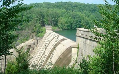
START: MWP - Meadowood Regional Park -- Ride Terrain: Rolling With Hills, Ride Leader's Pace: 16 mph, Regrouping: Some, Rest Stops: Snack, Rain Cancellation: Precipitation >60%
We ride to Liberty Dam, taking the Dam access road down, up, and down to the Dam overlook at mile 24. Bring a snack to enjoy as we appreciate the 84 billion gallons of water being held back by the Dam. We then ride up, down, and up the access road before doing a fine descent on Wards Chapel. Our return takes us over the seldom ridden, and very pretty Granite and Offutt Rds to a snack stop at Royal Farms at mile 35. We return Old Court to Falls Rd for about 2800 ft of climb overall.
Garb a fresh download while you are here:
https://ridewithgps.com/routes/46489327
Tcx url: https://ridewithgps.com/routes/46489327
Saturday, August 01, 2026
START: Skyline High School, Front Royal, VA -- Ride Terrain: Very Hilly, Ride Leader's Pace: 15 mph, Regrouping: Some, Rest Stops: Snack
This is a hilly, very scenic out-and-back on Skyline Drive in Shenandoah National Park. Skyline High School is ~1 mile from the Park entrance (milepost 0) in Front Royal, VA. We'll ride to Skyland Lodge (milepost 42) and back. We will also stop and re-group at Elkwallow Wayside (milepost 22) on both the outbound and return.
There is an entrance fee for bicycles to enter the Park. I will have a Park pass that will allow 4 bikes to enter.
While the climbs are not steep, they are long and sustained, with a total elevation gain of 8,500' - 9,000'. Expect to ride slower here than at home in Baltimore!
Tuesday, August 04, 2026
START: MWP - Meadowood Regional Park -- Ride Terrain: Rolling With Hills, Ride Leader's Pace: 16 mph, Regrouping: Some, Rest Stops: Snack, Rain Cancellation: Precipitation >60%
Ride from Meadowood to Rocks Park. Starts Jerome Jay to WesternRun before heading east to Rocks Park. Snack/lunch break at mile 42 Jarrettsville Creamery. Returns south via Baldwin Mill to Moores and Greene then Loch Raven to Seminary. We find some hills amongst the rollers for 5000 ft.
Weather or extreme atmospheric conditions (code Red/Purple) may change route.
Grab a fresh download while you are here:
https://ridewithgps.com/routes/41021063
Tcx url: https://ridewithgps.com/routes/41021063Tuesday, August 11, 2026
START: MWP - Meadowood Regional Park -- Ride Terrain: Rolling With Hills, Ride Leader's Pace: 16 mph, Regrouping: Some, Rest Stops: Snack, Rain Cancellation: Precipitation >60%
Roll west from Meadowood past Liberty Reservoir in search of Morgan Run. Snack at High's mile 22.
https://ridewithgps.com/routes/56172228
Tcx url: https://ridewithgps.com/routes/56172228Thursday, August 13, 2026
START: Nabil's House -- Rain Cancellation: Go No Matter What
All BBC members may attend; seating is limited however, so please RSVP with BBC President Nabil Ali. A Zoom link will be available upon request.
Agenda items should be sent to BBC president ahead of the meeting.